 |  | ||||||||||||||||||
 | |||||||||||||||||||
 | |||||||||||||||||||
Click on maps for larger versions | |||||||||||||||||||
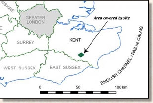
REGIONAL MAP (after OS) | |||||||||||||||||||
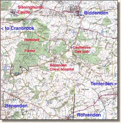 | |||||||||||||||||||
MAP OF THE WEBSITE AREA (courtesy Ordnance Survey). The main area is the diamond-shaped area bounded by main roads in the lower half of the map. Since it contains such a large area of woodland, we loosely include the belt of forest and woods (green on map) stretching from the Forestry Commission's Hemsted Forest in the northwest to the patches of woodland east of the old Castletons Oak pub. These woods occupy the high ground on the map (75-100m), while the diamond shaped area of agricultural land to the south slopes gently down to the low ground (<25m) between Tenterden and Rolvenden in the southeast. (Ignore the line pointing up from the bottom next to "Rolvenden". It's an old pointer and will be removed one day) | |||||||||||||||||||
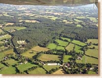 | |||||||||||||||||||
Vew of area looking southeast -- basically from top end of large map above). The plane was flying above the road to Cranbrook west of the Castletons Oak pub. The wood in the foreground is the one between Hemsted Forest (out of view to right) and the pub. The "diamond-shaped" area referred to under the map is visible under the wing. | |||||||||||||||||||
New June 2007 -- Google Maps with hi-res imagery Goodle Maps has just put up detailed satellite imagery for southeast England, so we're now able to provide an annotated map of the website area. The map is in "Hybrid" form -- i.e. combined satellite and map. Change to "Map" view if that's what you need. You'll also need to change the scale to see details of some features marked. Use the left hand panel to find marked items. Clicking on an entry in the panel will activate the corresponding marker on the map. The panel entries can't be ordered (yet!), so they're in the order they were written. One day. Google Map for the website area. The resolution of the imagery is astonishing. I'd estimate it's between one foot and 15 inches (30-40 cm), and definitely a lot less than one metre. This is not enough to resolve people walking (i.e. end-on to the camera/sensor), but cars are well represented and occupy several pixels, enough to show windscreens (but not number plates!). Sheep in the fields are also picked up as white blobs, as are slightly larger bales. Running alongside a road I was amazed to see telephone cable. Was this an artefact? Apparently not. It runs in shallow loops between (invisible) poles, following the road for some way before crossing it and disappearing in trees. This is the black rubber-insulated cabling that's about an inch in diameter. It must have been reflecting the sun and so shows up as a thin pale line. This line does exist down there! I know because I drive the road frequently. I've seen a Tawny Owl sitting on it at night. On top of that the imagery appears to be natural colour, which is an advance over the artificially coloured hi-res imagery previously available and a huge improvement on the old LandSat imagery, from which false-colour imagery could be made that ranged from quite true to pretty gruesome. Also the LandSat imagery never had a resolution better than 25 m. With "Maps" and "Earth" Google's providing one hell of a tool set. I hope to be able to use them to illustrate the area better -- for example by showing topogaphy in 3D. But first I'll have to upgrade my old G4 -- again! Oct 2007: Computer system's now upgraded so I can use Google Earth to tilt the satellite maps to view a pseudo landscape from any angle. This facility has still got quite a way to go imho. The effect is like a flight simulator but not nearly as good as the detail at any distance is (very) poor and only the area where the viewing axis meets the ground is in focus. Topographic detail is also rather limited (too few data points). But the potential is huge. | |||||||||||||||||||
powered by owls | |||||||||||||||||||